SF Cyclotouring

Ride reports and other ramblings from a San Francisco cyclist.

2/21/2009

San Francisco Randonneurs 300k Brevet, 2009 Edition

On the Cross-Marin Trail in SP Taylor Park
Distance: 198 miles
Bike: Kogswell 700C P/R
Time: 5:15am - 11pm; event time 16 hours.

A few people have inquired about how the 300k brevet went, so I figure I'd better get off my duff and write up a report about it. All in all, I don't really have that much to say, simply because -- unlike the 2007 edition -- the ride went off without a hitch, with medium temps throughout the day and almost none of the forecast rain. Lack of drama makes for fairly uninteresting reading!

Gabe and Bryan showed up at my place just after 5:15am, as planned. They'd picked up another rider along their way to my house (unfortunately I forget his name), and the four of us made our way from the Mission, up Polk Street, and out through the Presidio to the ride's start at the Golden Gate Bridge. After signing in and picking up our brevet cards, John rolled up as we were waiting for the pre-ride announcements to start. While listening to the speech, I saw Greg and Carlos across the group of assembled riders, but that would be the only time I'd catch sight of those two throughout the day.

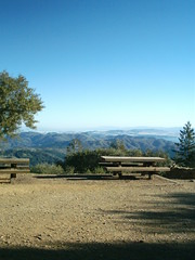
6am came and we were off. Gabe, Bryan, John, and I had done a very enjoyable ride a couple of weekends prior to the 300k and we all agreed that, since we seem to work well together, we should try to stick together on this day as well. So the four of us rolled out as a group, and even when Bryan's headlamp loosened up at the north side of Camino Alto, we all stopped and waited while he re-tightened it. We continued, rolling through the many small Marin towns on our way to Fairfax, and then on through Samuel P Taylor Park. Since it was still early and traffic was light, we opted to take the paved road through the first third of the park, instead of turning off over Inkwells Bridge and then taking the dirt road. At the campground, we picked up the Marin Cross-Valley Trail as usual, stopping for a break at one of the several convenient facilities along the paved path.

We left the early-morning quiet of the park, and headed up past the Nicasio Reservoir towards Petaluma. For a short bit, we found ourselves in the company of some of the visiting riders from Seattle Randonneurs -- one of whom had just picked up a beautiful custom Steve Rex randonneuse with a white paint job and contrasting black components -- including a black SON28 hub.

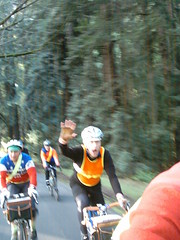
While paused at the "not-so-secret" control along the way to Petaluma, I snapped a few pics of the assembled riders, and we were off again towards the next stop, the Petaluma Safeway. I think I grabbed a donut, a banana, and a chocolate milk there, which I wolfed down and then we were off again. From Petaluma the route levels out into mostly flat secondary roads that wind through small communities -- easy and uneventful riding, really. I think at this control we picked up a fifth member of our merry band, Raj a rider from Reno. He stuck with us throughout the day and took many turns pulling strongly at the front (thanks Raj!).

We arrived at the Healdsburg Safeway, which served as the fourth control, and also since it's the impromptu lunch stop, many riders were assembled out in front of the store. Two years ago I staggered inside and made my way to the restroom, only to look in the mirror there and discover that I was covered with streaks of gritty road/rain-water from head to toe -- a frightful sight. Today was much kinder! I made the same stop, grabbed a sandwich and a drink (new secret weapon: Starbucks Doubleshot Energy + Coffee, whoa it packs a wake-you-up wallop!), and rejoined my friends out front at a table.

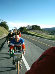
We lingered for a while, enjoying our lunch and the day, but then it was time to go. The five of us rolled out, just behind Kitty G, who we'd sync up with again later on. My favorite part of this 300k route comes after Healdsburg, and I was looking forward to it: after winding our way over to the Russian River Valley, we enjoyed some quiet and scenic back-country roads that wind through several vineyards. There are almost no cars on this part of the route, the roads form gentle rollers which keep things interesting, and trees line most of the road forming a nice green canopy overhead. Bryan lost a water-bottle cage screw somewhere along here, and our group splintered a bit as a few of us stopped while Bryan made repairs.

We rejoined our group at the turnoff towards Hwy 1 and the Pacific Coast. Tired now, we lingered next to a farmer's field, munching snacks and chatting. The skies over the coast looked darker and the wind was picking up, and I think nobody was really looking forward to the next part of the ride -- I know I wasn't. In 2007, nasty headwinds pummeled Carlos and I as we made our way down the coast, unabashedly drafting behind Mike B. since we both were beat. I hoped that today wouldn't be a repeat of that scenario...

We remounted and covered the last few miles out to the coast. While it was windy and gray, it wasn't raining, and the winds weren't too bad. We rolled along the coast, enjoying the pounding surf and the scenery of cliffs and random small beaches nestled among them. Soon we were in Bodega, where we stopped at the next control, Diekmann's Bay Store -- this is an odd but good store, as they have almost anything a hungry rando could want, including pizza, deli sandwiches, and fried potatoes and chicken! Of course we stopped here to refuel.

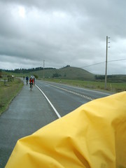
Our next destination was Marshall, home of the Marshall Store and its famous clam chowder. I was growing worried because that place closes at 5:30-6pm, and I didn't think we had enough time to get there from Bodega before then. It's about 23 miles between the two stores, but it always seems to take a long time to get from one to the other. We continued on through Valley Ford and Tomales, and came upon the Marshall Store to find it still open and with other randos inside. I grabbed a small chowder and a Coke, and joined my companions outside eating outside. We finished up just as the sun was setting, and everyone switched on lights as we set out again.

It didn't get truly dark until we turned off Hwy 1 back onto Point Reyes-Petaluma Road. Folks were getting quite tired now and our group fractured a bit as a result. We all regrouped at the top of the hill next to the reservoir. Both John and Gabe had Schmidt Edelux headlamps powered by SON dynamo hubs, and I was truly impressed with how effective those lights were. Riding in front of Gabe, many times I thought he was a car approaching from behind me! And when we were riding as a close group, I left my own headlight on low beam since their pair of lights provided plenty of light. The Edelux lights are pricey, but they are very good indeed!

We passed by Rancho Nicasio and entered the tall trees before the climb up and then the drop down to Sir Francis Drake Blvd. This section is perhaps the darkest point of the entire ride, since the trees overhead block any moonlight and there are no streetlights to speak of. In 2007 I struggled through this section with weak, waterlogged headlights, but I had a much better time of it this year, with my much stronger home-made dual LED headlamp. It started to sprinkle a bit as we worked our way over this hump, but by the time we reached Sir Francis Drake Blvd, the rain stopped.

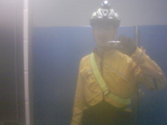
We slogged over White's Hill and back into Fairfax. I purposely descended White's Hill somewhat slower than I normally do, since it was dark and the roadway was wet. I later learned that another rider crashed on this descent and broke his collarbone, so I'm glad I was extra-cautious! We made our way back through the small Marin towns (San Anselmo, Larkspur, Ross, etc.), making a brief water stop in Larkspur. As we approached the Camino Alto climb, the sprinkles started again, and at one point I actually donned my rain jacket, but of course by the time we were in Sausalito again the rain stopped.

We climbed up out of Sausalito, crossed the bridge, and reached the finish just shy of 16 hours after we started. The five of us finished within a minute of each other, too, so we truly completed the ride as a group, audax-style! It was a great way to spend the day -- thanks to Gabe, Bryan, John, and Raj, along with all the SF Randonneurs volunteers who made the ride possible!

2/20/2009

Bicycle Headbadges

Whilst browsing for Centurian bike pics, I just came across this neat photo set on Flickr of various bike head badges. I thought it was a colorful, interesting collection!

2/19/2009

Two Years and 185 Miles Ago...

Wet & Tired & Nearly Done!Two years ago this coming Saturday, I did this. Two years later, I'll be doing it again!

2/17/2009

The Incredible Shrinking Man...

For the past several years, my weight has consistently hovered around 140-144lbs. Over the past few months, this number has been trending downwards, hovering in the 136-138 lb range. This morning, I weighed 134.2lbs, which is the first time I've dropped below 135 as an adult. Even when I was 23-24 (14 years ago) and riding to work 20 miles a day, six/seven days a week, and had a disgustingly-voracious appetite, I weighed about 139lbs. No idea why this is happening, I still generally eat like a horse, and though I'm often riding big miles on the weekends, my mid-week riding has basically dropped to zero -- no bike commuting lately, due to a dumb combination of cold/rainy weather and frequent early-morning meetings. In other words, my activity level during the week is nil. I basically feel fine/normal otherwise, except none of my pants fit anymore. I pinged my doc about this, and he said that there's usually no reason for concern unless your weight drops by more than 10% (~14lbs in my case). Maybe I just need to eat (more) doughnuts...?

2/15/2009

Santa Rosa CX Weekend


On the road
Originally uploaded by jimgskoop
Distance: ~25 miles
Bike: Austro Daimler Vent Noir
Time: 2-3 hours

Traveled up to Santa Rosa over the weekend to watch Cyclofiend and Chico Gino get their bikes muddy during some cyclocross action. Also got to meet Roy, Renee, and Paul, drink some good beer, eat a lot of food, and oh, squeeze a bit of ridin' in during a break in otherwise-constant rain.

2/11/2009

Route from Last Weekend's Century

There's been a lot of interest, so here's (roughly) the route we took for last Saturday's epic century ride.


(We took the loop counter-clockwise.)

2/09/2009

Ouch.


I have a walnut-sized saddle sore on my ass from Saturday's ride. Oops!

2/07/2009

Gabe's Birthday Century


Jon, Gabe, Bryan
Originally uploaded by jimgskoop
Distance: ~102 miles
Bike: Kogswell 700C P/R
Time: 9amm - 7pm

Met up with Gabe, Jon, and Bryan at Box Dog Bikes at 9am for a celebratory ride of Gabe's design. We wiggled over to Golden Gate Park and then out to the Great Highway, where we headed south and enjoyed views of big surf crashing over Ocean Beach. We climbed up Skyline towards Daly City, and zigged over on a couple of side streets towards Pacifica, where we left suburbia behind us, embarking on a little mixed-terrain discovery action, climbing up an abandoned, crumbling, overgrown roadway nicknamed "Planet of the Apes". Mountain bikers and hikers alike were astounded to see our four "touring bikes" on terrain more common to our knobby-tired brethren! At the top, we enjoyed views of Sutro Tower and Mt. Tam to the north, and Half Moon Bay to the south.

Descending now, we found our way back to civilization and connected with Highway One, rolling quickly along the coast to just south of Half Moon Bay. We made a left turn and headed inland onto Tunitas Creek Road. Up, up, and more up! We climbed slowly up this never-ending, winding rural lane, which had been newly repaved in expectation of many faster wheels than ours during the upcoming Tour of California, which is scheduled to follow this same route a couple of weeks from now. Halfway up we paused hungrily at a roadside turnout for a hasty lunch produced from our handlebar bags. Many other cyclists out for training rides passed by and hailed us as we ate. One lone rider pulled up and said hello -- we'd bumped into Willy N., a fellow member of San Francisco Randonneurs! After chatting for a bit, the five of us resumed our ascent. Bryan, newly refueled with some magic grub, jumped off the front of our group, and Willy leap forward to catch. Gabe and I toiled upward, when suddenly someone called out behind "anyone got a pump?!?" I slowed and wheeled around to investigate...

A lone cyclist had a soft front tire. "Is it low or flat?" I asked her. "I dunno" she replied, "I just noticed that it was low." "Flat" I immediately thought. No tube, tools, or pump had she, but fortunately one of her companions wheeled up to us just then, and had a tube to offer. I grabbed my pump and tire levers, and after whipping off her front tire, discovered a tiny hole and a guilty shard of glass lodged in the tire. Replaced tube, inflated tire, and we were all shortly back on our way. Tunitas Creek Road finally lessened its pitch, allowing me to upshift a gear or two, but still seemed endless as I followed it alone through the trees, finally coming upon my group where they were waiting at the intersection of Skyline Blvd.

Across the roadway was King's Mountain Road, and we debated which direction to take in the chilly air. To the right was the famed Alice's Restaurant, left was to follow Skyline north to Route 92, and straight was a fast drop down towards Woodside. We decided to head to Woodside and all donned all our layers in preparation. Willy said goodbye as he headed south, and we plunged downward, enjoying a long coast downhill, ending up at the Woodside Bakery next to Buck's Restaurant. Gnoshing on coffee and pastries, we warmed in the afternoon sun before continuing on Canada Road. We passed the Pulgas Water Temple (which was unfortunately closed) and arrived at the Crystal Springs reservoir in what felt like short order -- I'd ridden this road many times years ago while living in San Mateo, and it felt longer then. After a short stop where we compared our bikes and decided that they all -- each about the same size and with similar low-trail front geometry -- handled quite similarly, we headed north on the Sawyer Camp Trail, which winds around and along the twin reservoirs.

In Millbrae now, we discovered that the last northern section of Sawyer Camp Trail is closed for pipeline work, forcing us to ride along 280 until the next exit (bikes are legal for that stretch). We rejoined Skyline Blvd., aka Route 35, and descended past Daly City towards home in the dwindling daylight. Just before we approached Ocean Beach the sun set for good, and we switched on our headlights and enjoyed the quiet darkness of Golden Gate Park as we re-entered the city. Just as we arrived back at the Box Dog shop, I noticed that my bike computer had gone dead. I got back home just after 7pm, almost exactly ten hours later, just as I'd predicted. Gabe texted me a few minutes later, "102 miles". That felt about right to my tired legs and exuberant spirit!

2/01/2009

Fat Tire Ramble


West Point Inn
Originally uploaded by jimgskoop
Distance: ~50-55 miles
Bike: Bontrager Race
Time: 1pm - 6pm

Had a slow start to the day, but I finally convinced myself to get outdoors and pedaling... The previous day I'd considered what/where to ride, and decided that a dose of off-road action would be a healthy prescription after the previous weekend's 200k. You know, cross training! Normally I'd saddle up the Fuji CX for this type of ride, but I started having this funny idea that the Bonty might be more fun -- or at least a good way to mix things up. That bike hadn't seen daylight since last October, and its chain was clean and freshly lubed (vs. the Black Grime of Early Death on all the other bikes) -- so a knobbly, fat-tired day seemed in order...

The day before, I'd thought about tackling the traditional mixed-terrain route, but I didn't/couldn't get my gears a-turnin' early enough for that. Besides, I have some (odd?) phobias about riding that far into the boonies alone! I definitely wanted to reach West Point Inn to spend at least a few minutes languishing in the sunshine and chase away some recent mental clouds; I also wanted to pack as much climbing into today's ride as possible. I finished packing my gear, tossing a cold slice of leftover pizza into my Camelbak for a hasty lunch, and rolled out after addressing the flaccid tires.

Those wheels buzzed like a swarm of angry bees as I rolled over the Golden Gate, and I started asking myself "Headlands or Railroad Grade?!?" I'd grossly mis-judged the weather and stopped at the north end of bridge to shed a layer, top and bottom. As I continued and climbed up out of the parking lot, my brain's gauge locked firmly dead center: "Both!" -- so I wheeled left and headed slowly up Conzelman Road. Inspecting the views of the bridge and the mouth of San Francisco Bay to my left, I noticed a large, white blimp drifting about. At any rate, after rounding a couple more curves, I arrived at the Coastal Trail access gate. As I paused to drop the pressure in my tires for better off-road grip, I noticed another MTB rider consulting what I guessed was a trail book.

I made my way down this winding trail, noting that the surface seemed looser and sandier than I'd remember it -- perhaps there'd been some recent trail work done here? I rode the brakes around a particularly nasty off-camber curve, making sure to keep my distance from the sheer ledge a few feet away, and marveling that riding-pal Carlos always flies down this same path. At the bottom, I crossed Bunker Road and rolled through the parking lot towards the opening for Rodeo Valley Trail, but to my surprise the trail was blocked off with a fence and a "Trail Closed" sign. There were confusing detour instructions posted on the fence -- "take Miwok Trail to Bunker Road" or some such. I was trying to get to Miwok Trail, which lay just beyond the blocked trail head! Just at that moment, two riders emerged from behind the fence. I hailed them: "Is the trail open?" "Yeah, only the bridge is closed, don't know why, it's only a few meters..." they replied. So, we both snuck behind the fence, and sure enough, Bobcat Trail was open on the other side. I accelerated down the trail, and that other rider kept pace -- I could spot him in the rear-view. We passed a horse, some hikers, and a couple of other bikers as the trail's pitch increased. My breath grew raspy as I downshifted and strained against the pedals -- still he was there! After winding around a few more bends in the trail, I looked back, and my temporary companion was nowhere to be seen...that gave my ego a mischievous little boost! A couple more climbs brought me to the top of the Headlands, and I started the fast descent down into Tennessee Valley. I slowed for a couple of riders climbing their way up, and then started slowing again for a couple of hikers, a man and a woman. As I approached, the man started pointing exaggeratedly -- I thought perhaps there was a snake sunning itself along the trail. I slowed further, keeping on the lookout, and as I drew near the couple, the man gave the thumbs-up sign and said "Good job!" I replied with my usual "Howdy" (one of the guys in my college bike club, Matt Frey, used this greeting during rides, and I guess it's stuck with me), and the guy quizzically said "Howdy?" in response. In hindsight, I suppose the guy was trying to direct me around them with his pointing ("pass us HERE") -- he might've been previously buzzed by high-speed dual-boingers ripping down the trails. If that's the case, it's unfortunate! I always try to adhere to the IMBA trail guidelines, always yielding to horses and hikers, and any bikes climbing the trail that I'm descending.

I arrived in the parking lot at the base of Tennessee Valley, and then wound down the road towards Sausalito. After a short cruise on the Mill Valley Bike Path, I continued on Miller Ave past Mt Tam High, towards Mill Valley proper. Picking up Blythedale Blvd, I made my way past the opulent residences towards the Old Railroad Grade trail head. Railroad is a long, slow dirt-road climb up the side of Mt. Tam -- it follows a former railway so it's never too steep, but the slope is consistent. My right knee started twinging a bit during this climb, and I remembered that the Bonty's seat was set lower than my other bikes. I stopped near the turn-off for Hoo-Koo-E-Koo and adjusted the saddle upwards about 1cm (the black tape marking the seat post's insertion now stood proud from the seat collar), and then continued on my way up the trail. The saddle height felt significantly better, and I was happy to arrive at West Point Inn to rest in the sunshine and enjoy my simple lunch.

After a short break, I was ready to bomb back down the trail. I think my watch read about 4pm as I started off again, and I figured that it'd take about 30 minutes to roll back down. The gravity I'd fought on the way up paid me back with a swift, uneventful descent back down, releasing its grip on the bike just enough to get some air over the multiple whoop-de-doos (water breaks actually) that span the trail in several places. Back at the trail head and checking my watch, I was amazed that it only took about 20 minutes to fly all the way back down! Tires buzzing once again, I rolled back over the paved roads towards Sausalito, where I climbed up to the Golden Gate, rolled across it in the waning sunlight, and scraped back home just before the orange sky finally faded.

As I carried the bike back inside, I noticed that that strip of black tape on the seat post seemed much closer to the collar clamp than I'd set it. I grabbed the saddle and gave it a twist, and of course it moved! I took out my hex wrench, straightened the saddle, tightened the bolt as tight as I dared, and tested things again. Still it twisted! "Uh-oh" I thought. I dreaded a chronically-slipping seat post! After a shower for myself, I took the bike into the workshop, cleaned off the post and the inside of the seat tube (which was layered with an overzealous application of waxy Frame Saver), degunked the binder collar, lightly re-greased the post and the binder's clamping bolt, and finally reassembled, torquing that little M5 as much as I dared. Twisting the seat again, it did not budge! Hopefully good for now...we'll find out for sure next time!