Mixed-Terrain ride to Glen Camp with Carlos. Approximate route: Conzelman Rd to Marin Headlands trails to Miwok Stables to Muir Beach to Dear Park Fire Rd to Pantoll Ranger Stn to W. Ridgecrest to Bolinas-Fairfax Rd to Hwy 1 to Glen Camp to Olema then back home thru Samuel P Taylor Park/Sir Francis Drake Rd.
Approximate route map at Routeslip.comOur mission was to ride to Glen Camp -- a campsite within the Point Reyes National Seashore, for which we have a reservation on Oct 7th -- to scope out a possible route and check out the campsite itself. We didn't make it all the way to the campsite, deciding to head back 3.3 miles off target, but had a great ride all the same.
Friday evening called for homemade pizza and I sure ate my share -- half of a large pie! Then the agenda turned to cleaning, installing, and relubing the chain, plus reinstalling the trusty WTB tires on my CX bike. Packed a lunch, filled the Camelbak with water and the bike-bottle with Gatoraide, and got the rest of my gear sorted. I got to bed at the (for me) reasonable hour of midnight, but then one of our cats (Petunia) woke us up at 3:30am, I woke again at 4:50am and 5:30am. Finally at 6:30am the alarm sounded and I awoke without too much difficulty. I quickly got ready in the chilly predawn hours, trying to keep quiet while my wife slept. Grabbing an extra jacket to ward off the chill, I left nearly on schedule at 7:35am, heading towards the GGB to meet Carlos at the usual spot.
I got to the meetup point at 8:05am, and Carlos was already there of course. We chatted a bit as usual, discussing the fact that at even this early in the day, the temps were already climbing and it was unusually warm for this time of year in SF. I shed my extra jacket, packing it away in my Camelbak, and we rolled across the bridge towards the Marin Headlands.
After an uneventful bridge crossing, we turned left/up Conzelman Road, following a mountain biker taking advantage of the early morning sun and climbing swiftly. The last time I'd climbed up Conzelman I made good time and I was determined to repeat that again today. I shifted down a gear and upped my cadence to catch up with the mountain biker, but I never did catch him; my legs didn't have enough gas today -- a bad sign this early on which would haunt me for the rest of the day. Must've been all that pizza!
Just before the top of Conzelman Road, we turn off into the entrance to Coastal Trail. The unknown mountain biker is long gone by now, and Carlos is somewhere ahead as well. I
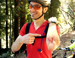
take my time here, cautiously picking my line through the gravel and rocks, somewhat
timid after my mild but mentally-jarring crash from last weekend's Labor Day ride. The trail finally drops down towards Bunker Road, and I reconnect with Carlos in the gravel parking lot near the entrance to Rodeo Valley Trail. This parking lot normally contains at least a few cars,but today it's deserted, presumably due to the still-early hour.
Rolling onward, Carlos and I decide to take the left fork onto Miwok Trail instead of our usual right onto Bobcat. It's roughly the same distance but I quickly remembered that Miwok climbs sharply upwards. My sluggish legs really dig in here, and I felt like I was dragging lead weights as I inched ahead in my lowest granny gear. We said hello as we passed a few folks out hiking in the warm morning air.
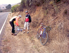
What goes up must come down, and down we went after all that climbing. From the hilltop, the trail drops down continuously as it winds into Miwok Stables. Damn -- my front brake starts
to screech and grind as I feel aluminum chunks from the front rim embedding in the brake shoe! As the trail enters the stable area at Miwok, I follow the sign's instruction, dismounting from my bike and walking it past the horsey areas so as not to spook anybody with four legs! I meet up again with Carlos and check my front brake.
After adjusting clothing, we continue on through Tennessee Valley, picking up another leg of the
Coastal Trail with a nasty double-false summit. More granny-gear cranking ensues! We descend again down the Coyote Ridge Trail towards sparkling views over Muir Beach.
Rejoining the paved world, we pass the Pelican Inn and turn left on Shoreline Highway. After a short distance we continue straight on Muir Woods Road and see some emergency signs for "15 minute delays" -- we figured they might be repaving the road or something. Unhindered by any road work, we approached the entrance to Deer Park Fire Road where we left the paved world again and started climbing up and up.
Deer Park is a favorite trail. It's a long climb -- about 2.5 miles from the road to Pantoll Ranger Station -- but it's never very steep, and it winds through trees and open spaces so there's god variety. About half way up there's a large fallen tree (a redwood?) that's been cut in half to
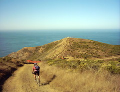
clear the trail and I always marvel at that. Near the summit Deer Park intersects with yet another leg of the Coastal Trail and that's a good place to regroup, snap some photos, and admire the view southward back across the valleys towards San Francisco.
The rest of the climb goes quickly since we're closing in on our lunch stop at the Pantoll Ranger Station. Carlos is far off in front by now and I figure that, by the time I get there, he'll have finished his lunch and will be packing up to leave. Fortunately as I roll in he's only refilling his hydro-pack and chatting with another cyclist. We note that there's many more road-cyclists in the area and lots of them have numbers pinned to their jerseys -- we learn from another
rider that some sort of hillclimb event is going on today. A few of the riders speeding down from Mt. Tam have squealing brakes and we hear them howling loudly as they slow the last few hundred feet on their approach to Panoramic Highway.
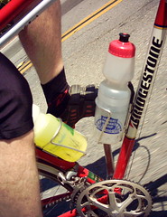
It's about 11am, perhaps a bit early for lunch but we're hungry! We walk our bikes up to a shaded picnic table and lay out the spread. It's warm in the sun but chilly in the shade and I'm forced to don both my fleece vest and my wind jacket from the early morning. I'm still feeling sub-par and as we eat I contemplate throwing in the towel and turning back for home, but ultimately I decide to continue, since the food perks me up a bit.
With hunger temporarily sated, Carlos and I continue up Mt. Tam on Pantoll Road. My legs are still leaden and Carlos pulls ahead. I see him again at the gate at West Ridgecrest Blvd, and we press on through the light brown grassy foothills surrounding Mt. Tam. The "NO SMOKING" sign and potential kindling all around us reminds me of Smokey Bear: "Only You Can Prevent Forest Fires". West Ridgecrest is a series of rollers that ultimately drops down to a peculiar intersection, where it connects with Fairfax-Bolinas Road and the Bolinas Ridge Fire Road. Last time we were here we took Bolinas Ridge, but today we're exploring a new way so we cross the oddly-located cattle-grate in the road (odd because there are no cattle in the area?!) and find ourselves on a road that descends for what feels like an eternity...winding down down down on a narrow paved road, my hands on the brakes tingling from squeezing so hard and wandering thoughts of "I wonder how hot my rims are right now?" and "Damn we're going to have to climb up out of this to get back home" in my head. We pass several packs of roadies spread out across the road, climbing UP this monstrous road and I don't envy them a bit. We also encounter a couple cars flying up hill and I hope they keep an eye peeled for those roadies as they zip around the blind corners!
As we approach Highway One we are treated to a delightful view of what must be the town of Bolinas and Bolinas Bay -- it's clear enough out that you can see the sandbar beneath the water that must be Duxbury Reef. I really wanted to snap a photo of this but speeds necessitate both hands on the bars, and my camera's memory maxed out a while ago anyways.
Finally on Highway One, we roll north along the coast, passing through Dogtown and looking for the entrance to the Olema Valley Trail. We must've passed the trailhead, so we press on via pavement and eventually reach Five Brooks. Coincidentally, my wife and I were here several
months ago to go horseback riding at the stables near the trailhead. We access Stewart Trail and find much evidence of horses, requiring nimble bike-handling skills to avoid. The trail sign said Glenn Camp was 5.6 miles from the entrance, which didn't sound very far at all. However, it was already after 1pm and we were 40-some miles into this ride, so time was becoming an issue. We pressed on...
Carlos and I got separated when I stopped to allow some equestrians to pass. I read somewhere that horses can get spooked by a bike's freewheel, which (to them) sounds like a rattlesnake's
rattle. Horses are also rather large critters with fairly small brains. So, I like to err on the cautious side, and I simply get the heck off my bike and stand stock still whenever one or more are around. That' s just what I did that day. In fact I had to do it a few times. Most of
the times the equestrian-people returned with a "Thank You" and "Nice day, how are you today" ("Yes, and Tired!" I replied) but once or twice they kept their heads down and talking at their horse and passed without so much as a nod. I suspect that bikes on these horsey-trails, while legal from a land-use perspective, weren't very welcomed by most of the folks. Lots of horse evidence (manure) and lack of bike evidence (tire tracks) back that assumption.
Aside from all the horse crap, Stewart is actually a pretty nice trail. It's wide, shady, and mostly hard-packed (a couple spots were sandy, no big deal) and you could probably drive a family car on it. Easy going really, as long as you watch out for the piles of poo in various shades of brown and green. Equestrians really should take a cue from dog owners and "clean up after your pet", but I imagine that would require a lot of plastic bags... Anyways, I digress. Where was I? Oh yes, the trail. Nice, wide, hard-packed, right -- these things were key since we're planning on riding loaded touring bikes here in a few weeks to get to our camp site. At Glenn Camp. Which should be just around the next corner it seems... This trail, although nice and wide and hard-packed, is also a thoroughly deceiving CLIMB. "Glenn Camp is accessed only by a 5.6 mile hike or strenuous bike ride" the information read, and I'm thinking "strenuous, yeah right!" until that point. It's a 5 mile climb well-hidden in the trees and the horse poop! After what feels like an eternity of crawling along with dead legs at 6 miles an hour, I finally catch up to Carlos waiting at an intersection. I look at Carlos, then look at the sign: "Glen Camp, 3.3 miles" it read, pointing off in one direction. I look at Carlos again: "You mean after all that we haven't even come HALF WAY yet?" "Nope" he said, and quickly followed with "I vote that we turn around here." I didn't argue -- that sounded fine with me! So we turned tail, and flew back down the trail. I think we got back to the roadway in less than half the time it took us to go up it. We didn't make it to Glen Camp but we got close enough I guess.
We trucked on towards Olema, which is not much more than the intersection of Highway One and Sir Francis Drake Blvd., complete with a flashing traffic light, a couple of restaurants, and a deli. I got the Kent Peterson Special: A Starbucks DoubleShot, a 1/2 pint of chocolate milk, a giant Reeses Peanut Butter cup, and a brownie. I bought all of this, ate it, and THEN remembered that I still had half a sandwich in my pack! Oh well, I was desperate for the sugar!
We spent a few minutes eating and basking in the sun before climbing up out of Olema on Sir Francis Drake Blvd. We picked up the Marin Cross Valley Trail and rode it into the park before discovering that it's STILL closed for some construction project (it's been closed all summer). We detoured onto the main road (SFD) through the park, stopping for water at the picnic area as usual. Any benefit from the sugar and caffeine I enjoyed in Olema were already gone, and I sucked down Gatoraide as fast as I could. I coaxed my tired body back on the bike as we headed for Fairfax. Somehow I made it over White's Hill and down into Fairfax, where I think I hit 40 mph on the descent (on fat 700c cross tires).
Of course we stopped for more fuel at the Java Hut in Fairfax. Sucking down an iced coffee, I noticed that Cannondale had a large canopy set up outside a truck/trailer across the parking lot. I didn't have the energy to go investigate, but it looked like they had a fleet of new bikes available for test rides. I thought this was odd because Sunshine Cyclery is just across the street -- I wonder if they're a Cannondale dealer?
The rest of the ride home was slow and relatively uneventful. I joked with Carlos that we should do a Paradise Loop to turn this ride into a 200k, and then patient as always, he waited for me as I drug my tired butt up and over Camino Alto. I tried to do a trackstand at the bottom while waiting for the light, and realized that my front V-brake had gotten skewed and was now rubbing on the rim. As I realigned the brake, in my delirium I worried that I'd somehow bent the fork or torn off a brake stud. Carlos assured me that it was probably just some grit in the works.
We continued on through Sausalito, noticing that it was unseasonably warm even this late in the day. Normally Sausalito is where we'd stop and add some layers in preparation for the chilly Golden Gate Bridge crossing but that wasn't needed today. I slugged my way up the climb to the bridge, rolled across it as best I could, and met up with Carlos at the usual spot on the other side, where we meet to summarize the day. As we were chatting, Patrick rolled up on his commute home from work, and we admired his newly-geared Rivendell with dyno-hubbed front wheel and huge Hoss saddlebag.
Finally it was time to go and I creaked on home. My bike's chain had picked up a lot of dust and grit during the ride, and even though I'd freshly cleaned and lubed the drivetrain the night before, it squeaked like an old grumpy Huffy as I rode home solo through the Presidio and then the Panhandle. I just hoped people wouldn't stare! I finally pulled up at home, tired but happy, with a total of 86 miles on the clock and nearly 11 hours gone. Not fast but definitely an epic ride! After a shower I took my wife out for BBQ at Memphis Minnie's up the street. Sweet-smoked pork, collard greens, and mac-n-cheese never tasted so good! Although stuffed, we splurged and got two desserts, even!
Date: 9.16.2006
Mileage: 86
Bike: Fuji Cross
Time: 7:30am-6:30pm